|
DAVID VOORHIS & ASSOCIATES
Data Research, Regulatory & Petroleum Engineering Consulting
|
|
| |
|
|
| |
< Previous Page >.......Page 9.......< Next Page >
|
|
| |
|
|
| |
IV. Petroleum Engineering Consulting Service
Oilfield Brine Fluid Migration Evaluation -
Finite Difference Simulation Example 2
|
|
| |
|
|
| |
| |
| |
Oilfield brine migration is a domestic oil industry problem that is commonly caused by the operation
of EPA Class II wells.. ..Enhanced oil recovery projects
(waterfloods, polymerfloods, CO2 floods, vaporizing gas drives, condensing gas drives and micellular floods) use
EPA Class II injection wells to sweep insitu oil towards producing wells....Water disposal wells are also classified as EPA Class II injection wells and are used to dispose of the
brine associated with oil and gas production.. ..Existing
Federal and State regulations require Area of Review (AOR) studies around EPA Class II injection and disposal wells.. ..These AOR studies are used to identify wellbores and boreholes
that might become conduits for injected fluid migration to fresh water sands....
Before any injection or disposal well has received government approval for injection, improperly plugged boreholes
and poorly cemented cased wellbores around the injectors are to be identified.... Once they are identified, measures are taken to ensure that they do not become a conduit for injected
fluid migration to fresh water sands.
The domestic oil extraction industry has a problem with EPA Class II injection projects because older wellbore
plugging practices have not been adequate to prevent plugged boreholes from becoming fluid conduits to fresh water
sands when exposed to the pressures from injection operations.... Many boreholes plugged prior to 1969 used mud as the plugging material..
..The mud within these boreholes has plastic characteristics that allows the mud to deform
when exposed to high enough injection pressures.. ..The
plastic behavior of the settled mud is mainly due to its high water filled porosity..
..Laboratory tests indicate settled mud porosity (the water volume between clay particles)
can be as high as 84 %.. ..When the injection zone pressure
is adequate for deformation, the mud used as plugging material elongates and/or compresses within the borehole.. ..The space vacated by the elongation and/or compression becomes
highly permeable flow channels.. ..At this point, the
improperly plugged borehole (i.e., one plugged with mud) can become a conduit for injection fluid migration to
fresh water sands.
Oilfield brine migration is a problem because oilfield brine can have salinity concentrations as high as 324,000
parts per million (ppm).... A typical upper limit for
total dissolved solids concentration in municipal drinking water is 1,000 ppm.... So, it is easy to see how oilfield brine migration into fresh water sands can increase the total dissolved
solids of fresh water to be greater than 1,000 ppm.
This page provides 8 illustrations from an Engineering Report of an area in North Central Texas... This area has a high potential for oilfield brine migration to fresh water
sands.. .The Texas Railroad Commission (TRRC), other
state agencies and the EPA have been informed of these problems.. .A lawsuit related to these issues has been initiated.. .Disclosure of these type of problems to authorities is a requirement of the Texas Engineering Practice
Act for licensed engineers in Texas.. .As a licensed
engineer in Texas, it is illegal to plan or implement projects that endanger public health, safety, welfare and
property....Because of the potential for fluid migration
to fresh water sands, it illegal for engineers to implement these type of EPA Class II injection / disposal projects.. .It is also illegal for others to implement these projects. .It should be noted that lease names, lease ID numbers, API numbers
and abstract numbers have been altered to lessen the chance of a lawsuit. .The eight figures are described in greater detail below.
|
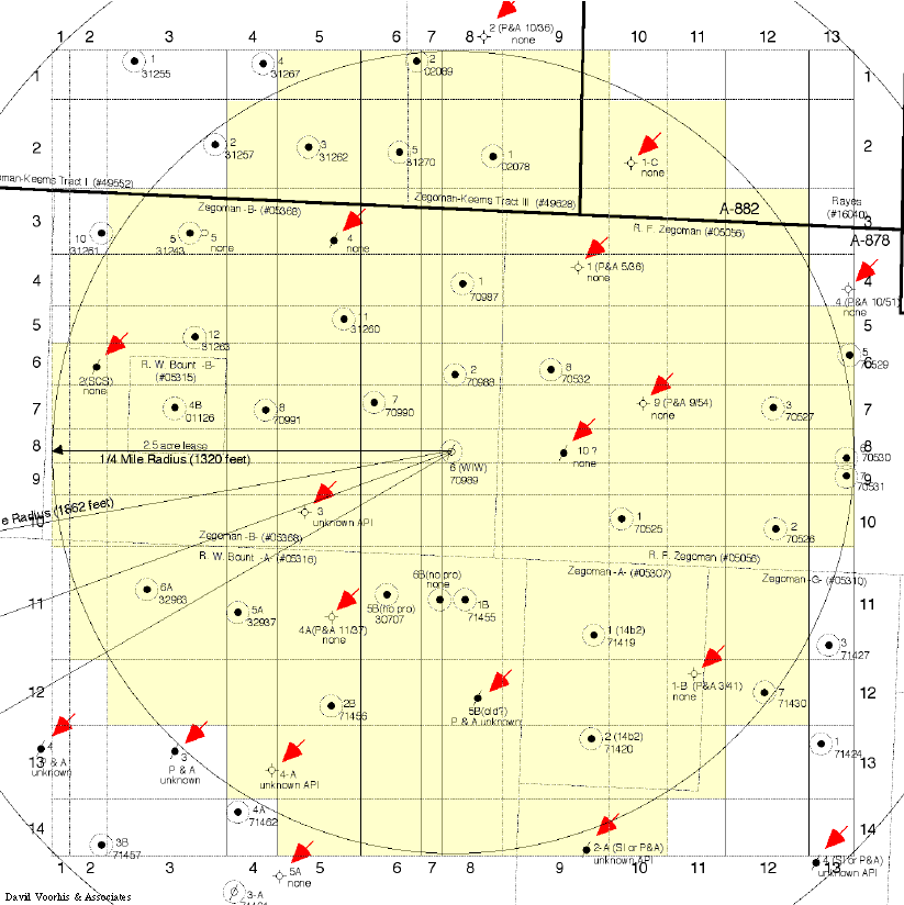
Figure 9.1
|
Illustrates one of the grid block configurations used to numerically simulate injected fluid migration
to the region's deepest fresh water, artesian aquifer....The
reservoir grid block configuration for this case is of the 1/4 Mile Area of Review for the Zegoman -B- Well No.
6. |
|
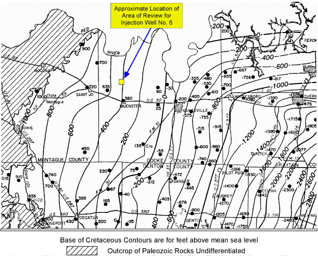
Figure 9.2
|
Is a regional map that illustrates the geologic structure of the Cretaceous Base and the general
location of the Area of Review for Injection Well No. 6. |
|
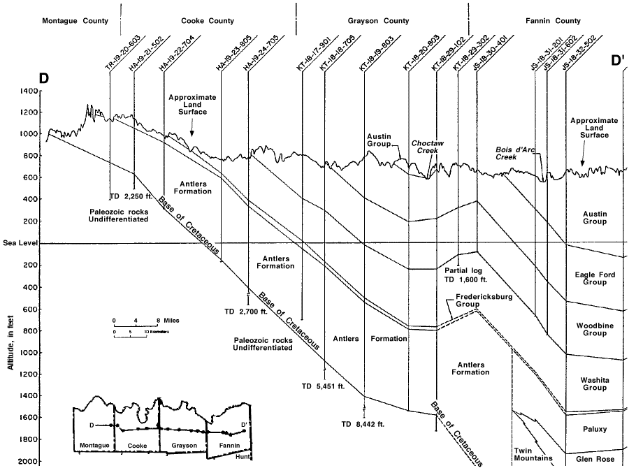
Figure 9.3
|
Is a regional cross-section that illustrates the geologic structure of the fresh water, artesian
aquifers endangered by the injection operations....The
lowest fresh water aquifer that can be affected by the injection operations is the Antlers formation. |
|
Figure 9.4
|
Illustrates the typical condition of plugging materials in an improperly plugged well ( R. F. Zegoman
No. 9 ) affected by injection into the Zegoman -B- Well No. 6. |
|
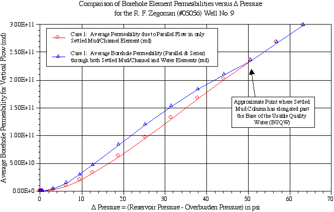
Figure 9.5
|
Illustrates the magnitude and the behavior of borehole permeability in an improperly plugged well,
the R. F. Zegoman No. 9. |
|
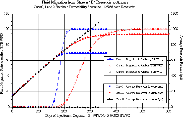
Figure 9.6
|
Illustrates the simulated fluid migration rates thought to be possible under existing physical conditions
and the authorized injection parameters for the Zegoman -B- Well No. 6. |
|
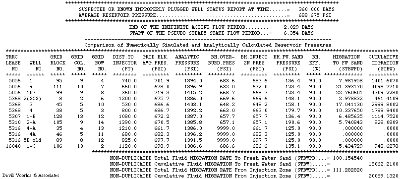
Figure 9.7
|
Is a computer output table of the possible fluid migration rates to the Antlers fresh water sand
after 360 days of injection. |
|
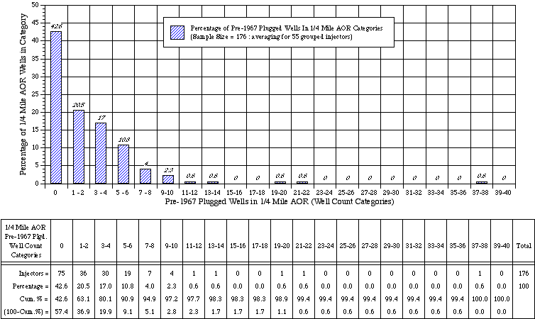
Figure 9.8
|
Reveals a histogram and table of approved Pre-1967 Plugged Wells (wells plugged with mud) within
1/4 Mile AOR's of Cooke County, Texas....The histogram
and table were developed from a survey of 176 EPA Class II injection applications approved by the TRRC during the
1985 to 1998 time period....This figure reveals that
57.4% ( 100 - Cum.% = 57.4% ) of the injectors approved during the 1985 - 1998 time period had wells that were
predominately plugged with mud within their 1/4 mile AOR's....These wells, the ones plugged with mud, are likely to become conduits for oilfield brine migration to
fresh water sands during injection operations. |
Figure 9.1 is a reservoir grid block representation of a 1/4 mile Area of Review (AOR) study area around injection
Well No. 6 (an approved injector).. ..The grid blocks
colored in yellow represent non-zero porosity grid blocks.. ..The red arrows indicate suspected or known improperly plugged boreholes..
..Reservoir simulations of the AOR were used to estimate the amount of oilfield brine migration
that could result from injection operations into Well No. 6.. ..As mentioned earlier, the improperly plugged wells have potential to develop into conduits
for fluid migration when the the injection zone pressure exceeds the overburden stress of the borehole material.. ..Within Figure 9.1, there
are 12 suspected or known improperly plugged wells within (or just outside) the 1/4 mile AOR circle. |
|
| |
|
|
|
|
|
|
| |
|
|
| |
Figure 9.1 : 1/4 Mile Area Of Review (AOR) Map Reservoir Grid for the Zegoman -B- Injection
Well No. 6
|
( RED ARROWS indicate Known or Suspected Improperly Plugged Wells )
|
| |
|
|
| |
|
|
| |
|
|
| |
|
|
| |
|
|
| |
| |
Figure 9.2 : Regional Map showing the General Area of Review location for the
Zegoman -B- Well No. 6 Injector
|
|
| |
( adapted from P. L. Nordstrom, Report 269 )
|
|
| |
|
|
|
|
| |
|
|
| |
|
|
| |
|
|
| |
|
|
| |
Figure 9.3 : Cross Section of Antlers Artesian Aquifer (Fresh Water Sand) Affected
by Injection Well No. 6
|
|
| |
( adapted from P. L. Nordstrom, Report 269 )
|
|
| |
|
|
| |
|
|
| |
|
|
| |
|
|
| |
|
|
| |
Figure 9.4 : Wellbore Diagram of a typical Improperly Plugged Well Affected
by Injection Well No. 6
|
|
| |
|
|
| |

|
|
| |
|
|
| |
|
|
| |
|
|
| |
Figure 9.5 : Borehole Permeability VERSUS Pressure Plot of an Improperly Plugged
Well
|
|
| |
|
|
| |
|
|
| |
|
|
| |
|
|
| |
|
|
| |
| |
Figure 9.6 : Plot of Possible Fluid Migration Rates to the Antlers Formation
due to Zegoman -B- Well No. 6 Injection
|
|
| |
|
|
|
|
| |
|
|
| |
|
|
| |
|
|
| |
|
|
| |
| |
Figure 9.7 : Computer output table of possible oilfield brine migration rates
after 360 days of injection in the Zegoman -B- Well No. 6
|
|
| |
|
|
|
|
| |
|
|
| |
|
|
| |
|
|
| |
|
|
| |
| |
Figure 9.8 : Histogram & Table of Approved Pre-1967 Plugged Wells (plugged
with mud) within 1/4 Mile AOR's of Cooke County, TX
|
|
| |
(from Survey of 176 EPA Class II injection applications approved by TRRC during
1985 to 1998)
|
|
|
|
| |
|
|
| |
|
|
| |
|
|
| |
|
|
| |
Click here to view Contact Information.
< Previous Page >.......Page 9.......< Next Page >
|
|
| |
|
|